-
Call Us (918) 426-6006
-
Email Us info@worldclassranches.com
Deep Branch Creek 735 - $1,869,400.00


Property Details
- Name of Property: Deep Branch Creek 735
- Status: New
- Price Per Acre: $2543.40.00
- Acreage: 735 acres
- Location: 75 mi. Tulsa; 250 Dallas; 2 hrs. Bentonville
- Closest Town: Webbers Falls
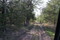
- Access: County Road
- Taxes: $691.43
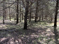
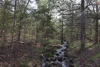
- Topography: Rolling forests
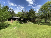
- Improvements: Some Fencing, and open areas for food plots
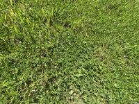
- Forage: Bermuda and native grasses, acorns
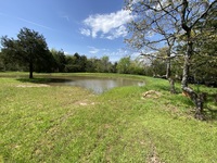
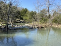
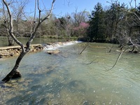
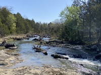
- Water: 1.7 miles of Deep Branch Creek
- Wildlife: Whitetail Deer, Turkey, & indigenous other
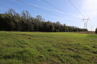
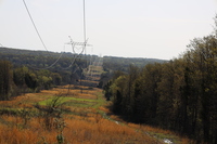
- Utilities: Electricity
Comments
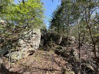
This 735-acres wilderness hunting haven is set up with a good trail system through most of the property that will accommodate a full size side-by-side. Deep Branch Creek runs for about One about 1.7 miles through the property. Three Corp overflow half-dams create sizable pools for abundant water supply for wildlife and fishing. The head waters of the deep Branch creek are from over 6 miles of tributaries and several miles of Bushy Creek water basin and its tributaries and underground springs. Power line right of ways provide excellent shooting lanes for long range rifle hunting. The understory is amazingly open for the avid bow hunters. Multiple food plots are already in place and utilized by the Whitetail deer and turkey. This is a bird watching paradise with sightings of a large variety of birds including Bald Eagles. Beautiful moss rock in a range of sizes are located on different areas of the ranch. The moss rock and flag stone could be a potential revenue source. Mature hardwoods including Oak and Hickory provide a nice canopy and cover for the wildlife and an abundant acorn crop for forage. The rolling terrain is reminiscent of the foothills of the Ozarks. Once you see it you can not un-see it!! By road the ranch is about 2.5 miles from the Illinois River, 4.5 miles to the Arkansas River and about 12 miles from beautiful Tenkiller Lake.
The outstanding views could be home to a number of Airbnb Cabin rentals or subdivided for hunting, fishing or a peaceful getaway. The existing trail system could also be used for Hiking and four-wheeler trails.
For personal use or family reunions. Hunting, fishing, 4-wheeler trails, hiking, camping – “One of a Kind”. This might be an “Excellent Real Estate Investment”!
Call Sandy Brock Bahe at 918-470-4710 or Toll Free at 844-WCR-LAND with questions or to view.
Location:
7 minutes to Gore, OK- Auto services, restaurants, groceries, supplies.
19 minutes to Interstate 40
Fort Smith AR 45 miles
Branson, MS 190 miles
Tulsa, OK 75 miles
Oklahoma City, OK 142 miles
Kansas City, MS 300 miles
Dallas, TX 250 miles
Muskogee, OK 30 miles
About Deep Branch “FishBrain blog”
Can you fish in Deep Branch? Deep Branch is a stream near Muskogee. At Gore landing area. The most popular species caught here are White bass, Largemouth bass, and Striped bass. 34 catches are logged on Fishbrain. Please use your best judgement when determining where you can fish, and make sure you follow local regulations.
Climate: TEMPERATURE PRECIPITATION OTHER FACTS WINTER WEATHER
Average Annual: 61 degrees Average
Maximum: 72 degrees Average
Minimum: 49 degrees
Highest: 115 degrees (Sallisaw, August 10, 1936)
Lowest: -19 degrees (Sallisaw, January 18, 1930)
Days of 90 Degrees or Higher: 67
Days of 20 Degrees or Lower: 19
Average Annual: 47.80 inches
Days With Precipitation: 85
Wettest Year: 75.93 inches in 1990
Driest Year: 23.35 inches in 1936
Greatest Daily Rainfall: 6.04 inches (Sallisaw, July 15, 1961)
Average Annual Snowfall: 7.2 inches
Days with snow on ground: 5
Greatest Seasonal Snowfall: 20.2 inches (1977-1978)
Greatest Daily Snowfall: 13.0 inches (Sallisaw, February 19, 1921)
Last Freeze in Spring: April 3
First Freeze in Autumn: November 2
Growing Season: 212 Days
Also Print & Download Complete Color Brochures. *Example of information to which you will have access.

320 E. Carl Albert Parkway, B1
McAlester, Oklahoma 74501